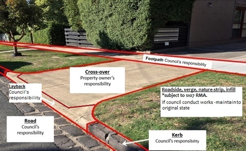
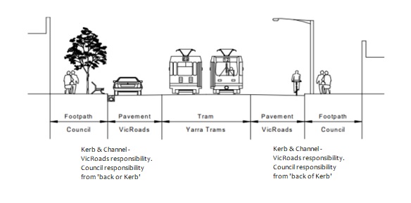
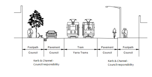
Your feedback is invited on our draft Road Management Plan that sets the standard for proactive and reactive management of our infrastructure assets such as roads, footpaths, the stormwater drainage system and trees for the next four years. The draft Plan was developed through feedback from the Asset Plan and Council Plan consultations in 2025.

Previously updated in 2021, the latest review aligns response times to industry standards and introduces proactive practices for signage, line marking and stormwater drainage pits.

Click here to read the draft Road Management Plan.

Infrastructure assets we manage

What's new in the 2026 Plan

  • Intervention levels and response times updated in line with current industry standards and Stonnington community expectations for quality infrastructure.
  • New Public Risk Assessment process to formalise the accelerated treatment of extreme and high-risk defects.
  • Proactive signage inspections.
  • More frequent routine visual inspection of bridges.
  • Proactive line marking inspections.
  • Proactive stormwater drainage pit inspections.
  • Proactive tree inspection frequencies.
  • Other obstructions impacting the network standards.

Click here to read the draft Road Management Plan.

About the Road Management Plan

What does the Plan cover?

The City of Stonnington manages and maintains all public local road infrastructure in the municipality and, under Victorian State Law, is required to set standards for repair and condition of roads. The standards balance good practice, community expectations, Council’s commitment to delivering quality community assets and the resources needed for infrastructure maintenance and reconstruction.

Infrastructure assets covered under the Plan include municipal roads, footpaths, kerbs and channels, road furniture (signs and line marking) and laneways.

The Plan generally applies only to public roads for which the City of Stonnington is the responsible authority and does not include private roads or driveways.

This draft Plan sits as a key strategic plan under our Asset Plan 2025-2035. The draft Plan was developed through feedback from the Asset Plan and Council Plan consultations in 2025. This consultation included a comprehensive community engagement process using the People's Panel - dedicated volunteers who participated in a series of workshops in February and March 2025 to undertake a review of the Asset Plan to ensure it continues to reflect the aspirations of the community and can provide clear guidance to Council.

The Panel expressed strong support for investment across all asset groups, emphasising the importance of adapting infrastructure to meet future challenges. Point allocations, along with key themes that emerged from their discussion, have been included in the draft Asset Plan.

Municipal roads

Council are the co-ordinating road authority for municipal roads.

See the diagram below for Council's responsibilities on municipal roads.

Arterial roads

Many of the major roads in the municipality are arterial roads managed by the Department of Transport and Planning so are excluded from the draft Plan. However, Council has responsibility from ‘Back of Kerb’. This includes the footpath.

To see a list of all the arterial roads managed by Department of Transport and Planning, click here.

See diagram below for Council's responsibility on arterial roads.

Diagram showing a street layout with footpaths, tram lines, and vehicle lanes, indicating responsibilities of VicRoads and the Council.

Council-maintained arterial roads

Chapel Street (Toorak Road to Dandenong Road), Darling Road, Chadstone Road and part of Kooyong Road are Council-maintained arterial Roads (i.e. under agreement with Department of Transport and Planning).

See diagram below for Council's responsibility on Council-maintained arterial roads.

Diagram showing a street layout with footpaths, tram lines, and council responsibilities for kerb and channel maintenance.

See the Register of Public Roads here.

Edit

Municipal Road Classification

Description

High Activity Areas

These carry higher volumes of traffic, including commercial vehicles, and often function as main routes for traffic flows in and around the municipality or high use due to proximity to main shopping areas. Key features typically include:

  • public transport routes
  • connectors to other higher order roads
  • cater for, but may restrain, service and heavy vehicles
  • proximity to main shopping district in council

Low Activity Areas

These carry only local traffic. The primary function is to provide access to private property. Key features typically include:

  • short distance travel to higher level roads
  • detached from main shopping district in council

Laneway

These perform a very minimal function as local access roads. Key features typically include:

  • a side or rear entry lane, generally providing secondary access to properties
  • low traffic counts and low speed

Inspection frequencies vary by the road hierarchy:

  • High activity areas are inspected bi-annually on a rolling basis
  • Most other assets are inspected yearly.

Appendix B in the draft Plan provides all inspection timeframes.

Defects are:

  1. assessed against intervention levels. An intervention level is the size or severity threshold at which a defect requires action (e.g. trip hazards over a certain height)
  2. prioritised based on risk
  3. scheduled for repair within response timeframes set out in Appendix C of the draft Plan.

An overview of response times to repair (business days) is below that vary depending on defect type and intervention level:

  • roadways - 20 to 45 days
  • footpath/pathways - 40 to 80 days
  • kerb and channel - 40 to 80 days
  • signs - 60 to 80 days
  • line marking - 80 days
  • street furniture and traffic devices - 80 to 120 days
  • drainage - 45 days
  • bridges - 150 days
  • other obstructions - 20 days.

Does the Plan guarantee roads will always be defect-free?

No. The Plan sets out reasonable inspection and maintenance standards. It’s not a guarantee of perfect conditions at all times.

Who is responsible for potholes after storms?

Council is responsible once aware (on municipal roads), but response times depend on severity and safety risk.

Why won’t you fix a footpath outside my house immediately?

Repairs are prioritised based on risk and intervention levels, not order of reporting.

Can residents repair footpaths themselves?

No. Unauthorised works within the road reserve are not permitted and may increase liability risk.

Is Council responsible for flooding on roads?

Council manages drainage assets, but flooding during extreme weather does not automatically indicate a failure to meet Road Management Plan obligations.

Who maintains bridges and culverts?

Council maintains bridges and culverts on municipal roads. Large drainage structures or waterways may be managed by Melbourne Water or another authority.

Is Council responsible for damage caused by service authorities (water, gas, NBN)?

No. The service authority is responsible for reinstatement, but Council may coordinate or enforce standards.

Does reporting a defect mean it will be fixed immediately?

Not necessarily. Defects are assessed and prioritised based on standards set in the Plan.

Can residents request infrastructure upgrades through the Plan?

No. The Plan covers maintenance and safety of infrastructure assets. It does not cover capital works or improvements.

Have your say

Complete the survey below by 11 March 2026.


Privacy Statement

The personal information requested on this form is being collected by Council for the purpose of facilitating the community engagement process. The personal information will be used by Council for that primary purpose or directly related purposes. For more information about how Council handles personal information, please refer to our Privacy Policy.